Map Info

A complete, desktop mapping solution for the geographic information system (GIS) analyst to visualize, analyze, edit, interpret, and output data — revealing relationships, patterns, and trends.
Confidently explore, model, and act
MapInfo Pro GIS software employs geospatial analytics and location intelligence to help you create insightful models of location-centric scenarios. Use these models to simulate different outcomes — then act with confidence.
Extract information from raster data
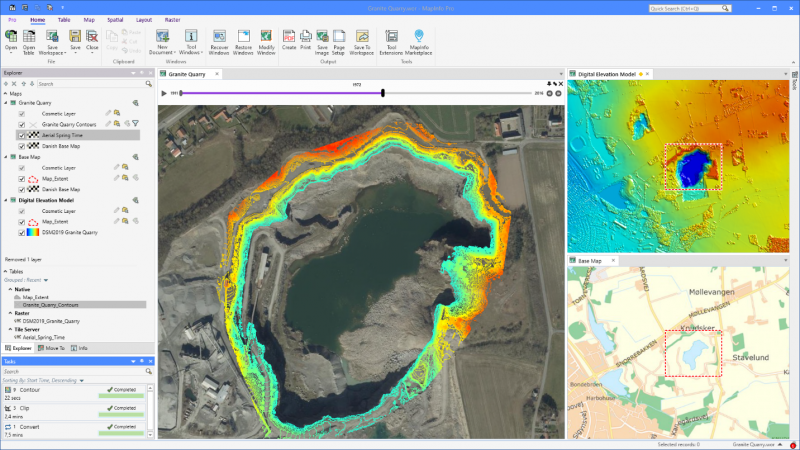
Creating optimum insights from large spatial files can be a significant challenge. Use our patented Multi-Resolution Raster (MRR) data format for powerful spatial processing and map rendering. Identify, quantify, and visualize spatial patterns in raster datasets of practically unlimited size. Or use our Multi-Resolution Virtual Raster (MVR) to virtually merge, reproject, and resample raster grid data on-the-fly, without writing out new grid files to disk.
Customize MapInfo Pro to meet your needs
Python Console: Increase productivity by building, running, and reusing customized applications. MapInfo Pro offers robust support for MapBasic and Python scripting languages.
Geocode: Take advantage of best-in-class geocoding from directly within the MapInfo Pro interface.
MapInfo Pro Viewer: Drive collaboration within your enterprise with the free MapInfo Pro Viewer. It allows line of business users to open any MapInfo workspace. Open tables in read-only mode and perform basic map operations such as pan, zoom, or reordering layers.
MapInfo Pro Drone: Commission project-specific data from a global network of more than 10,000 certified drone operators.
MapInfo Pro Drone: Make better decisions with better imagery

MapInfo Pro Drone is a simple, safe, and professional end-to-end drone data collection and mapping solution. Through a simple user interface built into MapInfo Pro, drone flights can be deployed almost anywhere in the world to collect high-resolution imagery, LiDAR, and video. Imagery can be collected in RGB, thermal, Infrared (IR), and multispectral, enabling a myriad of maps and digital terrain products to be produced. With improved, geospatial accuracy, sites and structures can be compared over time for maintenance issues, inspection of anomalies, remediation effectiveness, and for government compliance.
Leverage over 10,000 certified, professional drone pilots across the globe and gain access to custom imagery specific to your business needs with MapInfo Pro Drone.
For more details visit Precisely MapInfo Pro website
TerraGeo Technologies LLP is the authorized reseller of Precisely MapInfo Pro in India.