DAT/EM

TerraGeo Technologies is authorized DAT/EM software reseller in India, SAARC Countries, Australia, Vietnam & New Zealand located at Kolkata, India.

WORLD-CLASS PHOTOGRAMMETRIC WORKSTATION
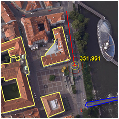
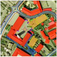
Summit Evolution provides a set of powerful tools for discovering and capturing 3D information from stereo data. The software includes CAD and GIS interfaces, 3D stereo vector superimposition, automated feature editing, contour generation and many more tools. Through the Capture™ interface for enabled Summit products, image features from a Summit Evolution project are digitized directly into AutoCAD®, MicroStation®, ArcGIS® or Global Mapper®. With DAT/EM Superimposition™, those image features are overlaid on the Summit Evolution project for immediate feature verification.
Summit Evolution is available in five product levels. Professional includes orientation measurement, orthorectification, terrain visualization, contour generation, point translation and DTM collection. Feature Collection is for those whose project setup, orientation and ortho processing needs are met elsewhere. Lite is a visualization tool designed for resource specialists, GIS technicians and QA professionals. Mobile is a variety of Summit Evolution Lite optimized for the field, but also available for desktop. Summit UAS adds the power of LandScape to Summit Evolution Lite in order toanalyze UAS data, including point clouds, in 3D stereo and collect georeferenced 3D vectors.
For detail information please visit below link of DAT/EM website.
Visit Now
3D POINT CLOUD VIEWING AND EDITING SOFTWARE
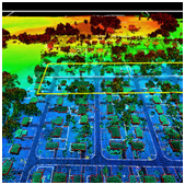
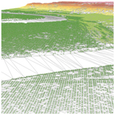
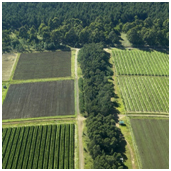
View and edit 3-dimensional point clouds using LandScape from DAT/EM Systems International to provide an advanced and efficient portal into one’s terrain dataset. LandScapeis capable of operating on very large terrain point clouds such as from LiDAR or SfM. The operator may choose options to view terrain datasets in stereo within LandScape in standalone mode or interacting with and superimposed over a Summit Evolution imagery project. LandScape contains a wide variety of automatic and interactive tools to enhance understanding of one’s data by creating, modifying and classifying points as well as drawing vectors based on those points. LandScape’s tools can be configured by the user to further enhance understanding of the data view.
Editing tools in LandScape allow easy modification of point cloud data including a single point, all points in a project or a selection built using LandScape’s filtering tools. LandScape includes the DAT/EM Drawing Tools, a simple built-in vector editor that collects, uses and saves vector features in a variety of formats. For more advanced digitizing tools, additional companion DAT/EM Capture™ modules may be added.
LandScape may optionally integrate with Summit Evolution™ to display the point cloud superimposed over stereo imagery. Use the Summit Evolution cursor to add, select and edit points, and to collect vector data.
For detail information please visit below link of DAT/EM website.
Visit Now
LOCATE MEANING IN YOUR UAS DATA
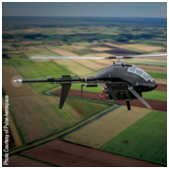
As a UAS post-processing toolkit, Summit UAS gives users control over their data. Summit UAS consists of two powerful applications, Summit Evolution Lite and LandScape, which among their many features offer ways to further explore and edit the point cloud and orthomosaic created by UAS processing software. The two products can be used separately to visualize and alter data or together to superimpose a point cloud onto stereo or orthomosaic imagery for targeted digitizing and editing tasks. Summit UAS is the right choice to explore and analyze your UAS data in 3D stereo and capture that understanding as fully-georeferenced 3D points and vectors.
For detail information please visit below link of DAT/EM website.
Visit Now